News & Articles
Browse all content by date.
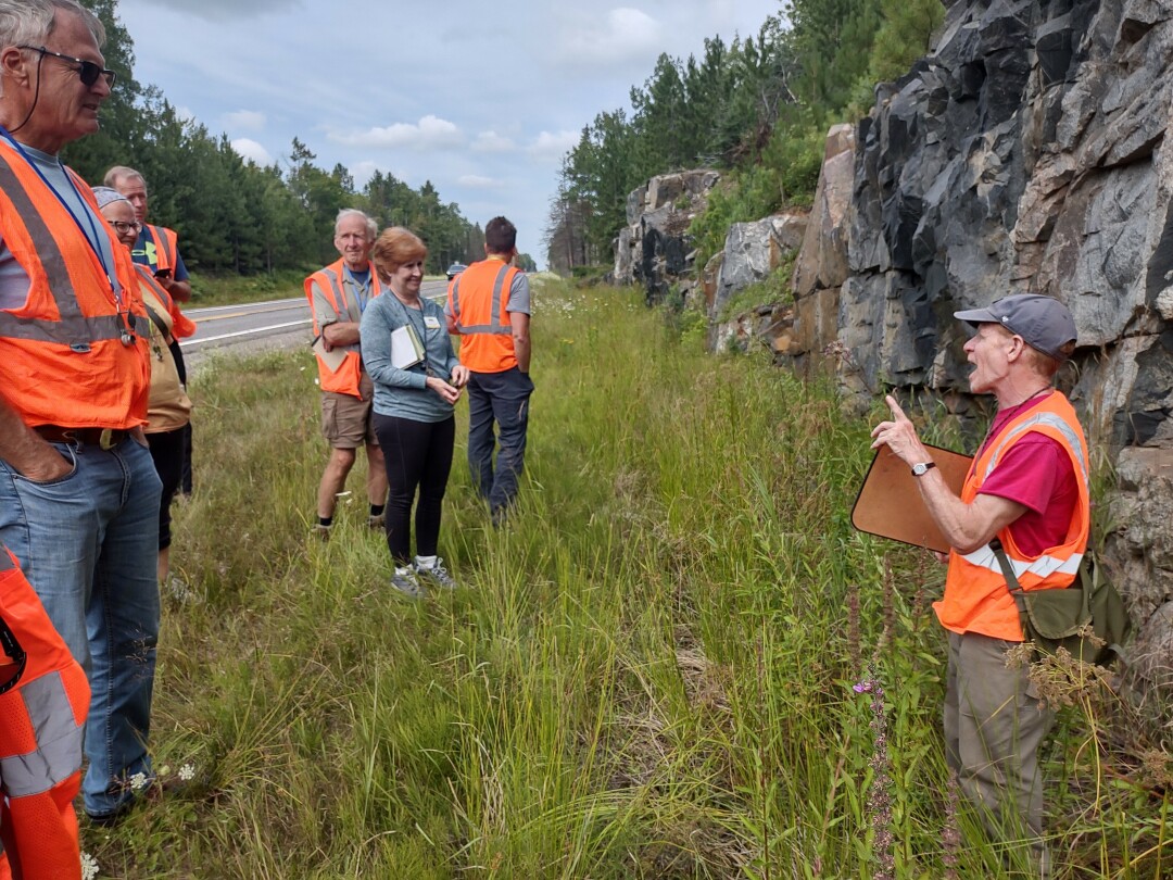 Tom Fitz explains how the rocks behind him formed as part of the Superior Craton, ancient heart of the North American continent. Photo by Emily Stone.
Even from the highway, we could tell that this rock outcrop was cool. Some sections were black, others were light gray, and streaks of both shot through it all. Twelve geologists, all in hi-vis safety vests, piled out of vehicles on the side of Highway 95 just north of Republic, Michigan. Luckily, the shoulder and ditch were both wide.
Tom Fitz, Professor of Geoscience at Northland College, instructed this group of Wisconsin Master Naturalists to explore the outcrop on our own for a few minutes. He’d made sure everyone was outfitted with a hand lens on a lanyard around our neck—the favorite tool of geologists and botanists alike. We waded through weeds and looked closer.
Why were Wisconsin naturalists in Michigan? This outcrop represents history common to us both…roughly 3.2 billion years before the state boundaries were drawn.
The 20-foot high cliff was window into the Superior Craton, one of the very first land masses to form when the planet was young. The original rocks likely included basalt from the ocean floor and volcanoes; granite from some of the first-ever continental crust; and mudstones formed as early Earth weather eroded rocks into smaller pieces and re-deposited them.
Then, they were all buried deeply by more rocks being piled on top and the actions of plate tectonics, heated to 600-700 degrees Celsius, and metamorphosed. Minerals changed. Molten rock of one type shot through semi-molten rock of another type to create cross-cutting streaks called dikes and sills. The basalt became deep black amphibolite, the granite became swirl-banded gneiss, and mudstones became shiny schist. Other land masses smashed into the craton, supercontinents formed and split, and the deep Earth churned during this complex and iterative process. “This rock has experienced a LOT of Earth’s history,” said Tom, in a bit of an understatement.
A student asked about the cracks and fractures in the rock, but Tom declared those fairly recent. Really deep, semi-molten rock doesn’t have cracks; hot rock is plastic. Not plastic as in Barbie, but plastic as in pliable and moldable, a favorite term of geologists. Instead, those fractures formed as erosion carried away 30-50 kilometers rock that had once piled on top. Rebounding from being unweighted, now cold and brittle at the surface, the bedrock finally cracked.
We had a night to sleep on this information, ensconced in the group site at Van Riper State Park. Janet made us pasta with fresh garden veggies. Donn and Andy pulled out their guitars for a singalong around a campfire. We metamorphosed some marshmallows for s’mores.
Driving into the morning sunshine, we found Marquette, MI, and walked a beautiful trail along the shore of Lake Superior to the very northern tip of Presque Isle Park. The rocks were dark and wrinkled, weathered into a texture like elephant skin. We sat down for Tom’s lecture, and boy am I glad I did.
“You know those old rocks we saw yesterday?” Tom asked. “Those were intrusive igneous rocks.” They cooled slowly, deep below Earth’s surface, so that the minerals had time to grow into big, visible crystals. “That means they had to intrude into an older rock that was already there. This is that rock.” With no radioactive minerals in the mix, geologists can’t figure out an age for this formation through radiometric dating, but we know that it’s older than the 3.2 billion year old rocks exposed near Republic.
Peridotite is a very dense rock formed directly from the Earth’s mantle. It was the ocean floor before there were continents. Most of its contemporaries would have been pulled by their own weight back down into the mélange of the mantle, remelted, and their chemical recipes evolved into the granites and other rocks we’d already seen.
“This rock has no business being at Earth’s surface,” admonished Tom. Even so, it was weathered billions of years ago at the surface of a very different Earth. The rough wrinkles we sat on were once at the surface of a very different Earth. Then it was buried. Now it is again exposed to the waves and wind of weathering, and to the feet and eyes of geologists who try to understand its story.
Our field trip didn’t end there. We explored banded iron formations that precipitated on top of those proto continents; the extensive lava flows of the Mid-Continent Rift; the sandstones that blanketed the landscape after that; and the glaciers that sculpted much of our current topography. These geologic events are all explained in our current Northwoods Rocks exhibit at the Museum. What isn’t explained there, is what it feels like to sit on 3.4 billion years of Earth’s history.
Emily’s award-winning second book, Natural Connections: Dreaming of an Elfin Skimmer, is available to purchase at www.cablemuseum.org/books and at your local independent bookstore, too. For more than 50 years, the Cable Natural History Museum has served to connect you to the Northwoods. Our exhibit: “The Northwoods ROCKS!” is open through mid-March. Our Fall Calendar of Events is ready for registration! Follow us on Facebook, Instagram, YouTube, and cablemuseum.org to see what we are up to.

| Tweet |