News & Articles
Browse all content by date.
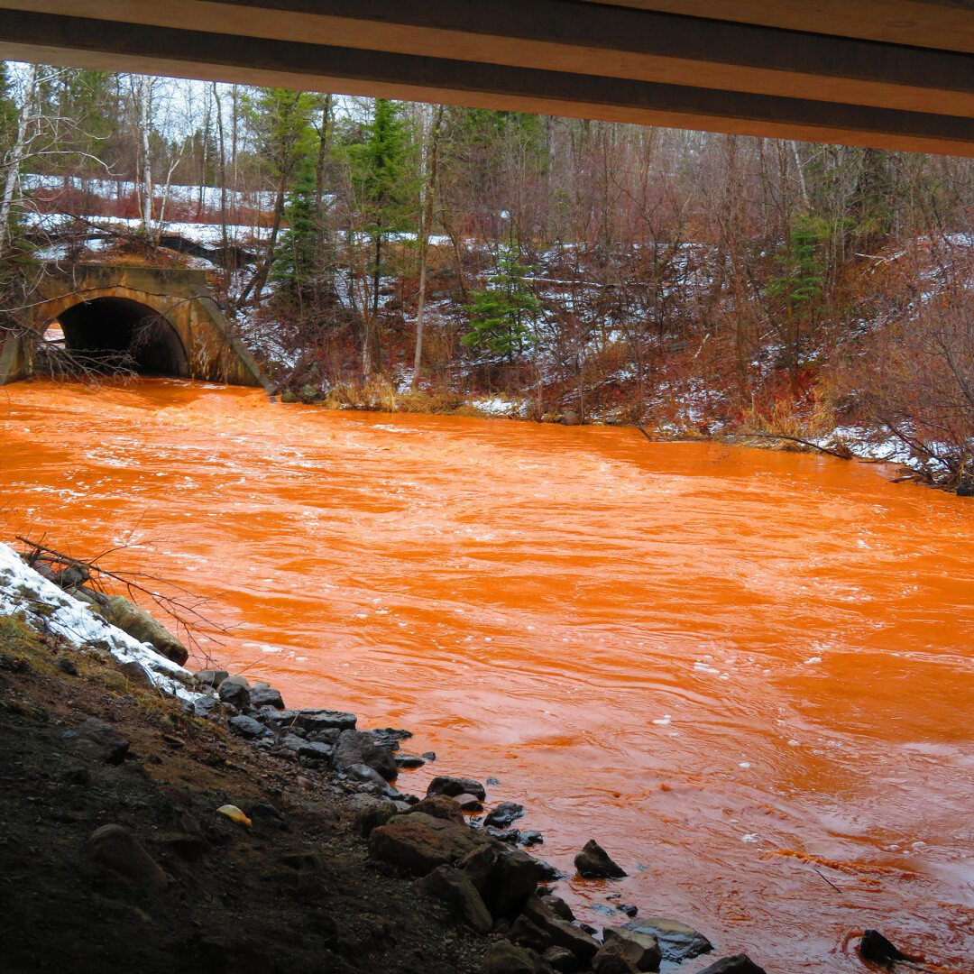
Runoff from the Hector Mine discolors the Embarrass River and Lake.
(Photo by Roy Glanville)
“We are lucky we didn’t have a much bigger catastrophe than we’re having out there,” St. Louis County Commissioner Thomas Rukavina said at the May 8 committee of the whole.
He was referring to the recent washout from the Hector Mine, a quarter-mile north of Biwabik. The long-closed mine is covered by a small, teardrop-shaped lake, which overflowed — or, “in the middle of the night exploded,” Rukavina said — on April 24.
The Iron Range Resources & Rehabilitation Board (IRRRB), which owns the land encompassing the mine, released an update of the washout May 4, stating, “Water that had pooled in the old Hector Mine compromised the embankment, causing a washout that cut a ravine about 30-50 feet wide and 20-25 feet deep, completely severed a portion of the Mesabi Trail, and continued toward the south where it met the Embarrass River Diversion Channel.”
“The material from the ravine dammed the river channel which temporarily blocked flow into the lake. Water and sewer lines, along with some utilities, were damaged and residences near Giants Ridge were impacted,” according to the update. The broken sewage line spilled an estimated 10,000 gallons.
The Embarrass River and a chain of lakes, normally tea-colored, turned a luminous reddish brown from the iron oxide and sediment in the mine.
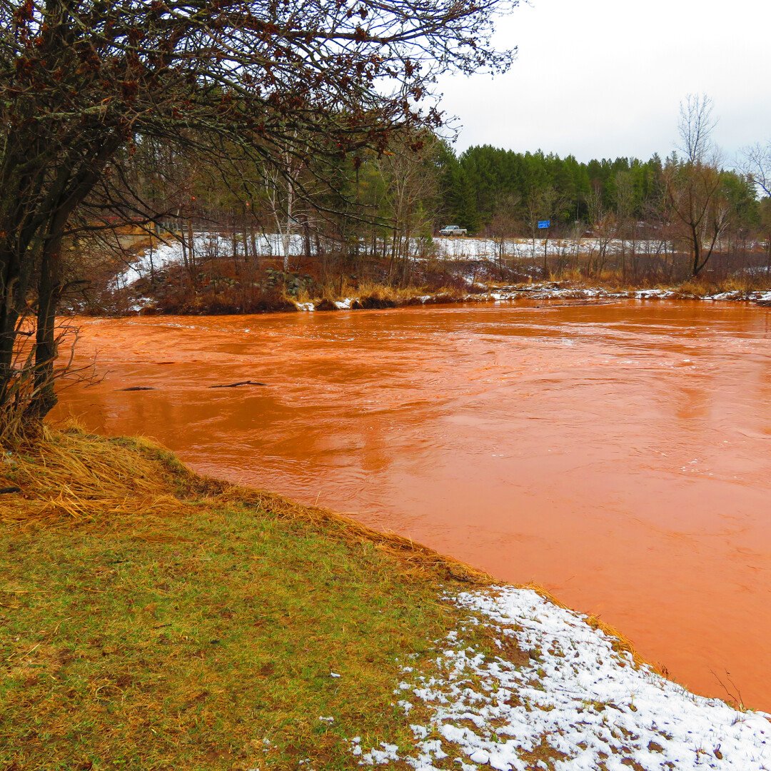
Photo by Roy Glanville
The washout also exposed a gas line. “So here’s this gas line hanging across this gully like a clothesline with the gas still running through it,” said Rukavina, who visited the site May 7.
“Natural gas service to the residents remains intact, although Minnesota Energy Resources (gas company) continues to work on a new 4-inch gas line beneath the bottom of the ravine,” according to the IRRRB update.
"We continue to closely monitor that segment that was exposed last month," said Matt Cullen of Minnesota Energy Resources. "Once the DNR and the IRRRB finish stabilizing the banks, we’ll install a new gas line." He expects the new line to be in place next week.
There’s little health risk, said John Thomas, compliance inspector for Minnesota Pollution Control Agency (MPCA), Duluth office. He said the sewage spill was stopped quickly and the pathogens soon die when exposed to elements. “Given the location, would anyone be drinking or swimming in the water this time of year?” he said.
The thick red silt in the water consists of clay and iron, “but I don’t have a reason to believe there’s something toxic there,” he said.
But the silt settles very slowly due to the extremely small size of the suspended particles. “The turbidity is not settling quickly, if at all,” he said. The MPCA will continue to monitor the water, which flows into Esquagama Lake and eventually to the St. Louis River.
The silt presents more of a problem to fish spawning. For species that do not tend their eggs — walleye, northern pike and yellow perch — the sediment can coat the eggs and prevent them from hatching. For nest builders like bass, sunfish and crappie, the sediments requires more effort to keep their nest clean. These species spawn later, so the impact depend on how long the silt remains unsettled.
So far there's been no evidence of the run-off killing fish, said Edie Evarts, Tower Area Fisheries supervisor for the Minnesota Department of Natural Resources. "It's superfine, but not enough to create a fish kill," she said. "Walleye and northern pike can live in muddy water."
Water first breached the raised embankment of the Hector Mine pit lake last November and took out a part of the Mesabi Trail, a paved biking/hiking path. The exact cause is unknown, but the drainage pipes had clogged. Likely factors include heavy fall precipitation, runoff from the surrounding watershed, beaver dams and other obstructions. A wet fall, followed by winter, postponed construction.
County Board Chair Keith Nelson blames the beavers. “Our wild engineers, those beavers that are out there, they washed out railroad trestles, they have washed out roads, they have washed out culverts,” he said. “They are the engineers of the ecosystem out there and they’re going to continue to be because you cannot possibly get ahead of them.”
The Minnesota Department of Administration gave emergency funding authority to Iron Range Resources & Rehabilitation, which funded the initial costs. Excavation contractor C & C Winger of Embarrass removed debris and restored water flow.
“It was frightening watching those wonderful equipment operators from Winger-Embarrass in there,” said Rukavina. “It was so saturated … they built a road down underneath that thing. You got a huge activator working up above trying to stabilize the ground. You’ve got his partner down below in an excavator trying to dig far enough back, and it’s so saturated.”
Initial reports named the Ajax mine as the spill source, though the IRRRB says that was incorrect information from a Facebook post.
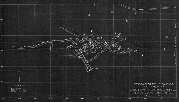
Map of the Hector Mine. (Source: MN DNR)
The Hector mine operated from 1893 to 1953, according to Skillings Mining Review. It is one of numerous closed mines that surround Biwabik.
“Mines were dangerous and accidents were almost daily occurrences,” according to 1977 report to the Minnesota Environmental Quality Board. “They were so frequent, in fact, that Biwabik residents sometimes referred to the mines as ‘the graves.’”
A 1992 article in The Minnesota Volunteer, a magazine of the Minnesota DNR, profiles Ed Miklausich, one of the last remaining residents of Hector, a now-vanished town near the mine: “When Miklausich’s father moved to Hector shortly before World War I, he started work in the underground mine. Plagued by cave-ins of the sandy overburden, the company converted the shaft to an open pit when heavier equipment became available. When a shaft collapsed in the underground mines, sand and mud occasionally entombed the miners. In the open pits, they occasionally lost fingers and toes to frostbite and entire limbs to the heavy equipment. ‘If they killed a donkey [in the mines], the men caught hell,’ one miner recalled. ‘If they killed a man — nothing.’”
The spill affected about 120 residencies, mostly condos and townhomes in the Giants Ridge Recreation Area. A boil-first water advisory was in place April 26-28.
Still residents did not lose water and sewer service, said Jeff Jacobson, City of Biwabik administrator. There was enough water in the Biwabik tower to maintain them until an emergency bypass connected to the City of Aurora in 72 hours. Trucks transport sewage from lift stations in Voyageurs Retreat and Giants Ridge until the line can be replaced.
Multiple entities — the IRRRB, MPCA, DNR, and the county — are responding to the washout. St. Louis County Administrator said the response “probably saved a number of homes.” Rukavina said, ”All those expensive homes, you know, they would have come here for abatements like you wouldn’t believe.”
After the May 8 committee of the whole adjourned, Commissioners Nelson and Rukavina asked Administrator Gray to research declaring the site a disaster area to get federal funds. “It is impacting a greater community up there. Water, sewer, expenses are starting to add up. It also impacted the Mesabi Trail,” Nelson said. “When it comes to federal emergency declarations there are a lot of hoops you gotta jump through. But we’re gonna look at it.”
Related article: When the levee breaks: Hector vs. Polymet

| Tweet |