News & Articles
Browse all content by date.
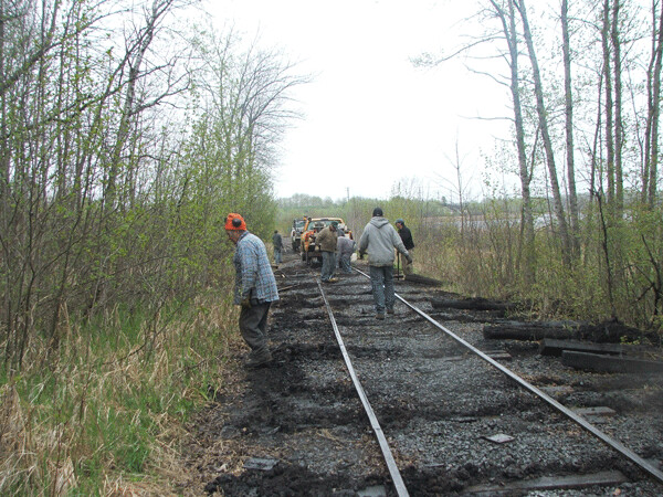
LSMR volunteers. Photo credit: John Ramos
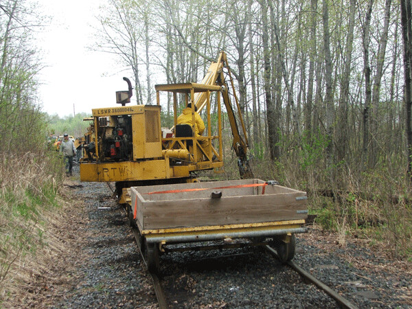
LSMR volunteers working on track near Gary. Photo credit: John Ramos
The US Steel cleanup project
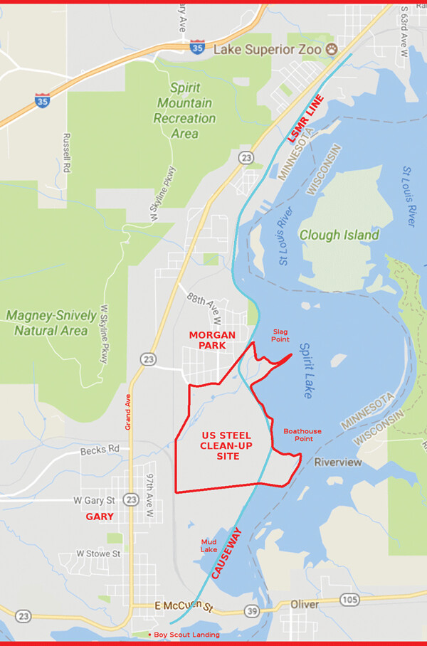
The old US Steel site in Duluth is 600 acres of heavily contaminated former industrial property situated along the St. Louis River west of Morgan Park. From 1915 to 1979, US Steel operated a vast complex of blast furnaces and steel manufacturing facilities on the site, employing 5,000 people at its peak. In those unenlightened days, waste chemicals and byproducts were dumped directly into the river. Today the belching chimneys and clamoring works are long gone. Officially closed to the public, the site consists of historical hardscape (slabs, footings, old metal pieces) and the occasional defunct streetlamp among grassy meadows and aspen groves.
The cleanup project is a $69 million undertaking spearheaded by the federal Environmental Protection Agency and US Steel. Many other agencies and stakeholders are involved, including the Minnesota Pollution Control Agency, the Minnesota Department of Natural Resources, the Fond du Lac Band of Lake Superior Chippewa, and the city of Duluth. In broad strokes, the plan calls for dredging contaminated sediments from the river, piling them on land, and capping the piles with earth. This will result in grassy berms up to 20 feet tall along parts of the river. The dredging will also create an area of shallow-water habitat in the river to foster the growth of wild rice.
In order to access parts of the US Steel site, work crews will need to use a city-owned railroad corridor which runs along the river. For the duration of the project, the train tracks will be covered with gravel and the corridor used as an access road. When the project is complete, the gravel will be removed and the tracks restored to their original condition. In return for granting US Steel/EPA this permission, the city will receive certain benefits. These benefits are currently under negotiation.
Some of the city’s requests to date seem likely to be granted. Part of the cleanup plan involves piling sediment atop an old man-made jetty, known as Slag Point, that juts into the river like a finger from US Steel’s shoreline. Currently Slag Point is a narrow peninsula of wet, low-lying forest and marshland. After the dredging and capping, Slag Point will be grassland elevated above the river. The city wants US Steel/EPA to construct a city park on Slag Point, as well as an access road from Morgan Park and an 18-car parking lot. US Steel/EPA has not raised any objections to this request.
According to a spokesperson for the EPA, work on the US Steel site is expected to begin in the winter of 2018-19. There is no firm deadline for the city and US Steel/EPA to have a final agreement in place, but the deal is expected to be done sometime this fall.

The Lake Superior and Mississippi Railroad
The mile or so of railroad track that passes through the US Steel site is part of a longer 6.2-mile stretch of rail that is the last surviving remnant of the Lake Superior and Mississippi Railroad, Duluth’s first railroad. Completed in 1870, this vital transportation link connected St. Paul to Duluth and opened the way for Duluth to grow from a wilderness outpost into a city.
It wasn’t a safe train originally. In Thomson, the LSMR began its long descent from the high country down to Lake Superior. Following the engineering practices of the day, the railroad followed the St. Louis River, curving and winding with its curves through a landscape of towering clay banks and ravines. Mudslides, washouts, and accidents were common. Today that area is Jay Cooke State Park.
The line leveled out in Fond du Lac and proceeded sedately the rest of the way to the Duluth waterfront, crossing portions of the river on low trestles. The longest of these was a trestle more than a mile long that crossed a wide, shallow section of the St. Louis River estuary known as Mud Lake. In the 1940s, the railroad replaced the trestle with earth and fill and turned it into a causeway. Today’s 6.2-mile remnant, which runs between the zoo and Boyscout Landing in Gary, includes the causeway.
Over the years, the LSMR line underwent name and ownership changes, eventually winding up owned by Burlington Northern (BN). The line saw a significant drop in use when other railroad lines were built into the city along better routes. It closed for good in 1949. In 1977, when BN was considering formally abandoning the line, a group of train enthusiasts petitioned the railroad to turn over the rail corridor to the city of Duluth. BN assented. Upon completion of the ownership transfer, the city granted use of the line to the Lake Superior Museum of Transportation, which the enthusiasts had established in 1973. In honor of Duluth’s first train, they changed the name of the line back to the Lake Superior and Mississippi Railroad. Using volunteer labor and donations, they fixed up the tracks. The first regularly-scheduled excursion of the LSMR as a tourist train took place on July 5, 1980.
The train museum, housed downtown in the historic Union Depot, continued to grow. In 1986, at the urging of the museum’s leadership, the Minnesota Legislature created an authority, the St. Louis and Lake Counties Regional Railroad Authority, whose purpose was to “operate a scenic tourist excursion railway in Northeastern Minnesota and create a paved multipurpose trail along abandoned rail lines” in Lake and St. Louis Counties. The Rail Authority was, and is, supported by a property tax levy (on your property tax statement, it’s lumped in with other miscellaneous levies in a category called “Special Taxing District”). The Rail Authority purchased 26 miles of rail between Duluth and Two Harbors that was set to be abandoned by the Duluth Missabe & Iron Range Railway. The North Shore Scenic Railroad was established to run on the tracks. The NSSR’s first train ride up the shore took place in 1990.
Not everyone was happy with the changes. As the focus of the train museum and city leaders shifted to the higher-profile NSSR, many of the people who had helped create the LSMR resisted. NSSR’s present-day president Ken Buehler told me, “What [the NSSR] didn’t grasp was the connection many of the volunteers on the railroad had built up with the LS&M line. They liked ‘their’ railroad and the jobs they had on it and decided to stay where they were in West Duluth.” The LSMR eventually broke away from the museum altogether and formed their own nonprofit.
Today, the two excursion lines are very different. The NSSR, based downtown in the Depot, is by far the more well-known of the two operations. It runs bigger trains on heavier rails and commands a much higher budget than the smaller, scrappier LSMR. The NSSR’s tracks are maintained by the levy-supported Rail Authority; the LSMR maintains their own tracks at their own expense. The NSSR has a paid director; the LSMR is entirely volunteer. The Depot receives funding from the city of Duluth tourism tax—$226,800 in 2017. The LSMR, for the first 32 years of its existence, received no tourism tax support. Finally, in 2013, at the urging of West Duluth City Councilor Jay Fosle, the city granted the LSMR an annual amount of $20,000 for their operation—one-eleventh the amount given the Depot. The two trains even run in opposite directions: The NSSR runs northeast along the shore of Lake Superior, the LSMR southwest along the St. Louis River. Of the two rides, the LSMR’s is the more scenic.
Today the two operations have a cordial relationship. Both groups seem proud of the fact that Duluth is the only city in the country with two excursion trains. Nevertheless, in comments that LSMR President Andy Webb made to the city council in June, he quipped, “We’re the nicer people. Our hearts are purer.”
The Western Waterfront Trail
The US Steel/EPA cleanup project intersects with another city planning effort: the extension of the Western Waterfront Trail (WWFT). The WWFT today is a graveled, wheelchair-accessible path that follows the shoreline of the St. Louis River 3.7 miles from West Duluth to Riverside, occasionally moving slightly inland. Since 1979, when the city commissioned an initial report on the subject, the idea of extending the WWFT further west along the river has periodically resurfaced. This extension would add another 9 miles to its length, running all the way to Chambers Grove Park in Fond du Lac. In 2015, the WWFT was given a boost when Mayor Don Ness established a city tourism tax designated for recreation projects in the St. Louis River corridor. With some of that money, the existing WWFT has been fixed and refurbished, with steep grades made shallower and invasive species removed.
The city views the US Steel/EPA project as an opportunity to add further extensions to the WWFT. As part of their agreement, the city is asking US Steel/EPA to fund construction of the WWFT along 1.4 miles of riverfront bordering the project site.
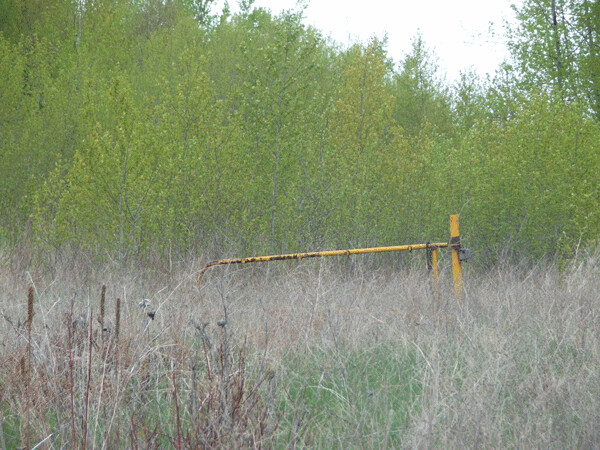
Ghost gate at the old US Steel site. Photo credit: John Ramos
Mud Lake and the MPCA report
Since 2008, the St. Louis River estuary has been experiencing what might be called an ecological renaissance. In that year, Minnesota voters approved the “Clean Water, Land and Legacy Amendment” to the state Constitution, which established a 3/8 percent sales tax for environmental restoration projects, among other things. John Lindgren, the St. Louis River Area of Concern Coordinator for the DNR, told the city Parks Commission in July that the Legacy Amendment had been a “godsend” for the river. “When we wrote [the St. Louis River restoration] plan [15 years ago] it was kind of a pipe dream. We’d love to do these things to clean up the estuary, but in my career I never imagined that we’d actually do them.” But since the Legacy Amendment was approved, “In the last 5 years our team of folks...has been able to secure $22 million to invest in restoration of the estuary.”
Projects that have been completed include the restoration of natural river flows and sturgeon spawning grounds at Chambers Grove Park; establishing hundreds of acres of wild rice beds in sheltered bays; restoring a mile of the heavily sedimented Knowlton Creek to a natural state; and removing hundreds of thousands of cubic yards of historical wood waste from Radio Tower Bay (in the early days of Duluth, sawmills lined the banks of the St. Louis River, churning out billions of board feet of lumber and dumping waste slabs into the river, which have been sitting there ever since). Projects in the works include more wood waste removal from Grassy Point and the restoration of Kingsbury Creek Bay.
Mud Lake, separated from the main river by the LSMR causeway, is an area of concern for environmental scientists. The lake’s sediments are known to be heavily contaminated with runoff from US Steel, but beyond that little information about the site is available. A 2013 report on Mud Lake prepared by the Minnesota Pollution Control Agency states as much: “Very little information exists about current conditions in Mud Lake. Investigations are necessary to provide baseline data to support understanding of a number of presumed impacts at the site and restoration planning.”
Currently, only one opening exists in the causeway to facilitate water exchange between Mud Lake and the rest of the river—a small trestle in the middle. The MPCA report suggests that water exchange might be improved by adding more openings in the causeway. John Lindgren is quoted: “A new channel would be created through the wetland north of Mud Lake East and through a newly established hydrologic connection through the railroad causeway....This type of a connection would greatly enhance water exchange to Mud Lake West, where having more openings along the railroad causeway along the open water section of Mud Lake East would most probably produce a strong water exchange. This would be a big benefit for rice restoration and for the general productivity and long term maintenance of the area behind the railroad causeway.”
Nevertheless, the report notes that its recommendations are entirely preliminary and conceptual, and based on best guesses rather than hard information. “There is no data to support the assumption that water exchange is limited between Mud Lake East and Mud Lake West due to the railroad causeway. To support definition of restoration objectives for improving water exchange, a hydrologic study should be conducted to define current conditions. The data collection plan should consider information needed for hydrologic model inputs.”
The mayor’s proposal
City staff has been negotiating with US Steel/EPA and meeting with community stakeholders since 2015 in an effort to tie all the different planning efforts together into a cohesive overall vision for the western waterfront. The process has been led by Jim Filby Williams, the city’s director of public administration, and his staff.
On June 13, 2017, Mayor Emily Larson unveiled her proposal. It was a surprise to everybody. Calling it “a compromise in many ways,” the mayor advocated completely removing the causeway from Mud Lake and ending the rail line at Mud Lake’s north shore. The Western Waterfront Trail would be extended around the shore of Mud Lake and pick up the now-abandoned rail corridor on the other side, which it would follow onward to Fond du Lac. The mayor stressed the environmental benefits of opening up Mud Lake and the social benefits of having a trail that allowed all people access to the river, regardless of income.
Jim Filby Williams explained how the city had reached its conclusion. “We consulted extensively with highly qualified natural resource scientists...and they spoke with one voice,” he said. “They said that notwithstanding the great historical value of the rail line, the placement of the rail line on the bed of the river has caused, and continues to cause, considerable harm to the health of the river, principally by cutting off the area on the inland side from the river at large, which has caused a major portion of what was once open water to silt in. And so the opportunity here, which is larger than virtually any of the other opportunities in the river, is to restore more than 90 acres of aquatic habitat.”
For those who had been following the issue, this was quite an unusual statement. If natural resource scientists were speaking with one voice, it was a very different voice from the one they had spoken with four years earlier. No further study or data collection had been done on Mud Lake since the 2013 MPCA report had come out. No hydrologic studies had been done to chart the river’s flows. So when did everyone decide that removing the causeway was better than putting openings in it? Where was the data?
LSMR supporters hated the plan. The causeway, they protested, was the “crown jewel” of their excursion train. Taking it out would chop 1.5 miles off the rail line and eliminate its most scenic and popular feature. When you considered that the rail line would also lose at least two seasons’ worth of operational revenue while the US Steel project was underway, removing the causeway could spell the end of the LSMR. In describing the issue to me, LSMR President Andy Webb likened it to “castration.”
Environmental professionals, by contrast, loved the plan. Daryl Peterson, an aquatic resource manager and conservation specialist with the Minnesota Land Trust, applauded the city for its work. “We’re changing the way we look at the river. We’re changing the way we interact with the river. We’re gonna change our city. I really applaud the city for all the work they have done to get to this point….I think they’ve done an incredible job trying to balance all of those interests, and I’d just like to thank them for the work that they’ve done.”
All of which raises an obvious question: If one side hates a compromise and the other side loves it, can it really be called a compromise?
What’s next?
There you have the public face of the story of the LSMR causeway. The city hopes to present a final plan to the Parks Commission in October, with a vote by the city council taking place by the end of the year. But readers might be surprised to learn that all is not as it seems. Next week, I will tell the true behind the scenes story that brought us to this point.
| Tweet |